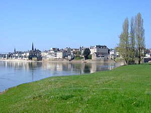
Ingrandes-Le Fresne sur Loire
former commune in Maine-et-Loire, France
üksikjuht nähtusest
asutamise või loomise aeg
1. jaanuar 2016
ametlik nimi
Ingrandes-Le Fresne sur Loire[2]
riik
located in statistical territorial entity
Q108921150
Q113842466
associated electoral district
canton of Chalonnes-sur-Loire
koordinaadid
valitsusjuhi ametikoht
Mayor of Ingrandes-le-Fresne-sur-Loire
õiguslik vorm
commune nouvelle
algusaeg: 1. jaanuar 2016
lõppaeg: 31. detsember 2023
rahvaarv
meessoost elanikkond
naissoost elanikkond
selle vahetas välja
Ingrandes-le-Fresne-sur-Loire
vahetas välja selle
Ingrandes
Le Fresne-sur-Loire
sulgemise või tegevuse lõpetamise aeg
31. detsember 2023
pindala
12,94 ruutkilomeeter
sihtnumber
49123
Commonsi kategooria
Ingrandes-Le Fresne sur Loire
kategooria selles kohas sündinud inimeste jaoks
Q113988763
category for maps
Category:Maps of Ingrandes-Le Fresne sur Loire
Viited
- ↑ 200060184
- ↑ Code officiel géographique, https://www.insee.fr/fr/information/3363419, 6. jaanuar 2019
- ↑ Sandre, https://www.sandre.eaufrance.fr/geo/CoursEau/----0000
- ↑ Populations légales 2020
- ↑ 5,0 5,1 The National Institute of Statistics and Economic Studies
- ↑ Loireauxence

