Fail:SA Sites.png
Selle eelvaate suurus: 656 × 599 pikslit. Teised eraldusvõimed: 263 × 240 pikslit | 525 × 480 pikslit | 801 × 732 pikslit.
Algfail (801 × 732 pikslit, faili suurus: 1,03 MB, MIME tüüp: image/png)
| See fail ja sellest kastist allapoole jääv kirjeldus pärinevad kesksest failivaramust Wikimedia Commons. | Faili lehekülg Commonsis |
| Kirjeldus |
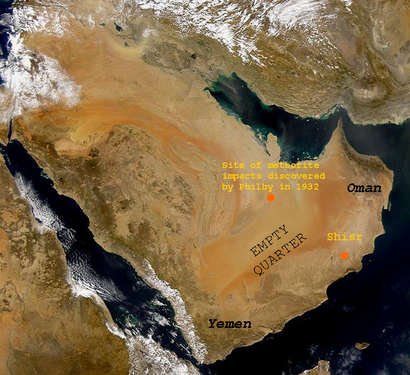
English: SeaWiFS collected this view of Arabia and of dust blowing across the Persian Gulf. Español: La Península Arábiga vista desde el espacio Suomi: Satelliittikuva Arabian niemimaasta |
| Kuupäev | (UTC), Pildistamisaeg 2. märts 2000 |
| Allikas | |
| Autor |
|
| See on töödeldud pilt, mis tähendab, et selle pildi tuletamiseks on algupärast pilti digitaalselt muudetud. Muudatused: Added text. Algupärand: Arabian Peninsula dust SeaWiFS.jpg. Muutnud Shaibalahmar.
|
Autoriõiguse omanikuna avaldan selle teose järgmise litsentsi all:
| This image is from the Sea-viewing Wide Field-of-view Sensor (SeaWiFS) Project and more than 5 years old.
Satellite data captured by the SeaWIFS sensor are released into the public domain 5 years after capture. Data less than five years old can be re-used only for educational or scientific purposes; any commercial use of such images must be coordinated with GeoEye. [1] |
| This work has been released into the public domain by its copyright holder, GeoEye. This applies worldwide. Kui see pole mõnes riigis õiguslikult võimalik: GeoEye annab kõigile õiguse seda teost kasutada ükskõik mille jaoks, ilma ühegi tingimuseta, kui seadus neid just ei sea.
|
This image is a derivative work of the following images:
- Image:Arabian_Peninsula_dust_SeaWiFS.jpg licensed with PD-SeaWiFS
- 2008-01-02T17:02:18Z Hautala 2504x2286 (873404 Bytes) {{PD-USGov-NASA}} * {{en|Satellite image of Arabian peninsula}} * {{es|La Península Arábiga vista desde el espacio}} * {{en|Satelliittikuva Arabian niemimaasta}} Taken from NASA's [http://visibleearth.nasa.gov/ Visible E
Faili ajalugu
Klõpsa kuupäeva ja kellaaega, et näha sel ajahetkel kasutusel olnud failiversiooni.
| Kuupäev/kellaaeg | Pisipilt | Mõõtmed | Kasutaja | Kommentaar | |
|---|---|---|---|---|---|
| viimane | 7. juuli 2011, kell 09:43 | | 801 × 732 (1,03 MB) | Shaibalahmar |
Faili kasutus
Seda faili kasutab järgmine lehekülg:
Globaalne failikasutus
Järgmised muud vikid kasutavad seda faili:
- Faili kasutus vikis en.wikipedia.org
- Faili kasutus vikis es.wikipedia.org
- Faili kasutus vikis sr.wikipedia.org