Fail:PIA21130 Signs of Schiaparelli Test Lander Seen From Orbit.gif

Algfail (1132 × 781 pikslit, faili suurus: 1,43 MB, MIME tüüp: image/gif, korduv, 2 kaadrit, 2,0 s)
| See fail ja sellest kastist allapoole jääv kirjeldus pärinevad kesksest failivaramust Wikimedia Commons. | Faili lehekülg Commonsis |
Lühikirjeldus
| Kirjeldus |
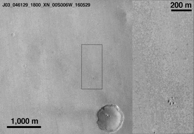
English: This comparison of before-and-after images shows two spots that likely appeared in connection with the Oct. 19, 2016, Mars arrival of the European Space Agency's Schiaparelli test lander.
The images were taken by the Context Camera (CTX) on NASA's Mars Reconnaissance Orbiter on May 29, 2016, and Oct. 20, 2016. The area indicated with a black outline is enlarged at right. The bright spot near the lower edge of the enlargement is interpreted as likely to be the lander's parachute, which was deployed and then released during the descent through the Martian atmosphere. The larger dark spot near the upper edge of the enlargement was likely formed by the Schiaparelli lander. The spot is elliptical, about 50 by 130 feet (15 by 40 meters) in size, and is probably too large to have been made by the impact of the heat shield. The location information confirmed by this image will aid imaging the site with the High Resolution Imaging Science Experiment (HiRISE) camera, providing more details to use in interpretation. The main image covers an area about 2.5 miles (4 kilometers) wide, at about 2 degrees south latitude, 354 degrees east longitude, in the Meridiani Planum region of Mars. The scale bars are in meters. North is up. The before and after images are available separately as Figure 1 (from CTX observation J03_046129_1800) and Figure 2 (from CTX observation J08_047975_1779). CTX was built by and is operated by Malin Space Science Systems, San Diego. NASA's Jet Propulsion Laboratory, a division of Caltech in Pasadena, California, manages the Mars Reconnaissance Orbiter Project for NASA's Science Mission Directorate, Washington. |
| Kuupäev | (published) |
| Allikas | Catalog page · Full-res (GIF) |
| Autor | NASA/JPL-Caltech/MSSS |
| Teised versioonid |
|


| Location on Mars | See ja teised pildid sellest paigast lehel: Google Maps |
|---|
This image or video was catalogued by Jet Propulsion Laboratory of the United States National Aeronautics and Space Administration (NASA) under Photo ID: PIA21132. This tag does not indicate the copyright status of the attached work. A normal copyright tag is still required. See Commons:Licensing. Other languages:
|
 |
This media is a product of the Mars Reconnaissance Orbiter mission Credit and attribution belongs to the MRO Context Camera (CTX) team, NASA/JPL-Caltech/MSSS |
Litsents
| See fail on avalikus omandis, sest selle autori NASA autoriõiguspõhimõtte järgi ei ole ilma vastava märketa NASA materjalid autoriõigusega kaitstud. (NASA autoriõiguspõhimõtted või JPL-i piltide kasutuspõhimõtted). | ||
 |
Hoiatused:
|
Faili ajalugu
Klõpsa kuupäeva ja kellaaega, et näha sel ajahetkel kasutusel olnud failiversiooni.
| Kuupäev/kellaaeg | Pisipilt | Mõõtmed | Kasutaja | Kommentaar | |
|---|---|---|---|---|---|
| viimane | 21. oktoober 2016, kell 21:28 | | 1132 × 781 (1,43 MB) | Ely1 | User created page with UploadWizard |
Faili kasutus
Seda faili kasutab järgmine lehekülg:
Globaalne failikasutus
Järgmised muud vikid kasutavad seda faili:
- Faili kasutus vikis de.wikipedia.org
- Faili kasutus vikis en.wikipedia.org
- Faili kasutus vikis es.wikinews.org
- Faili kasutus vikis fa.wikipedia.org
- Faili kasutus vikis fr.wikipedia.org
- Faili kasutus vikis he.wikipedia.org
- Faili kasutus vikis it.wikipedia.org
- Faili kasutus vikis ru.wikipedia.org
- Faili kasutus vikis ru.wikinews.org