Fail:MountCleveland.jpg
Selle eelvaate suurus: 800 × 538 pikslit. Teised eraldusvõimed: 320 × 215 pikslit | 640 × 431 pikslit | 1024 × 689 pikslit.
Algfail (1024 × 689 pikslit, faili suurus: 195 KB, MIME tüüp: image/jpeg)
| See fail ja sellest kastist allapoole jääv kirjeldus pärinevad kesksest failivaramust Wikimedia Commons. | Faili lehekülg Commonsis |
| Kirjeldus |
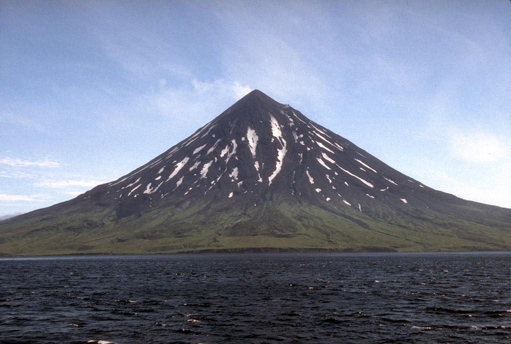
English: From the USGS caption: Mount Cleveland forms the western half of Chuginadak Island in the central Aleutian Islands. This symmetrical, 1,730-m (5,676 ft)-high stratovolcano and has been the site of numerous eruptions in the last two centuries; the most recent eruption occurred in 1994. In 1944, a U.S. Army serviceman was reportedly killed by an eruption from Mount Cleveland. |
||
| Kuupäev | |||
| Allikas | http://pubs.usgs.gov/dds/dds-40/ (image 94 of Volcanoes of the Alaska Peninsula and Aleutian Islands—Selected Photographs) | ||
| Autor | M. L. Harbin of the University of Alaska Fairbanks in a joint program, the Alaska Volcano Observatory, with the USGS[1] | ||
| Luba (Faili edasikasutus) |
|
Faili ajalugu
Klõpsa kuupäeva ja kellaaega, et näha sel ajahetkel kasutusel olnud failiversiooni.
| Kuupäev/kellaaeg | Pisipilt | Mõõtmed | Kasutaja | Kommentaar | |
|---|---|---|---|---|---|
| viimane | 31. jaanuar 2005, kell 11:38 | | 1024 × 689 (195 KB) | GarciaB~commonswiki | Mount Cleveland, Alaska |
Faili kasutus
Seda faili kasutavad järgmised 2 lehekülge:
Globaalne failikasutus
Järgmised muud vikid kasutavad seda faili:
- Faili kasutus vikis ar.wikipedia.org
- Faili kasutus vikis arz.wikipedia.org
- Faili kasutus vikis az.wikipedia.org
- Faili kasutus vikis be.wikipedia.org
- Faili kasutus vikis ca.wikipedia.org
- Faili kasutus vikis ceb.wikipedia.org
- Faili kasutus vikis cs.wikipedia.org
- Faili kasutus vikis de.wikipedia.org
- Faili kasutus vikis el.wikipedia.org
- Faili kasutus vikis en.wikipedia.org
- Faili kasutus vikis es.wikipedia.org
- Faili kasutus vikis eu.wikipedia.org
- Faili kasutus vikis fa.wikipedia.org
- Faili kasutus vikis fr.wikipedia.org
- Faili kasutus vikis hy.wikipedia.org
- Faili kasutus vikis id.wikipedia.org
- Faili kasutus vikis it.wikipedia.org
- Faili kasutus vikis ja.wikipedia.org
- Faili kasutus vikis ko.wikipedia.org
- Faili kasutus vikis lld.wikipedia.org
- Faili kasutus vikis ml.wikipedia.org
- Faili kasutus vikis nl.wikipedia.org
- Faili kasutus vikis nn.wikipedia.org
- Faili kasutus vikis no.wikipedia.org
- Faili kasutus vikis pt.wikipedia.org
- Faili kasutus vikis ru.wikipedia.org
- Faili kasutus vikis uk.wikipedia.org
- Faili kasutus vikis www.wikidata.org
- Faili kasutus vikis zh.wikipedia.org