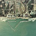
Fail:Fukushima I NPP 1975.jpg

Selle eelvaate suurus: 600 × 600 pikslit. Teised eraldusvõimed: 240 × 240 pikslit | 480 × 480 pikslit | 768 × 768 pikslit | 1024 × 1024 pikslit | 2511 × 2511 pikslit.
Algfail (2511 × 2511 pikslit, faili suurus: 1,15 MB, MIME tüüp: image/jpeg)
Faili ajalugu
Klõpsa kuupäeva ja kellaaega, et näha sel ajahetkel kasutusel olnud failiversiooni.
| Kuupäev/kellaaeg | Pisipilt | Mõõtmed | Kasutaja | Kommentaar | |
|---|---|---|---|---|---|
| viimane | 24. oktoober 2017, kell 11:43 |  | 2511 × 2511 (1,15 MB) | Togabi | Color adjustment. |
| 4. aprill 2011, kell 15:26 |  | 2511 × 2511 (1,17 MB) | 84user | Reverted to version as of 09:18, 15 January 2011 please make a new image page for such a change | |
| 3. aprill 2011, kell 00:32 |  | 2511 × 2496 (1,18 MB) | Hydrargyrum | lossless rotation 90 deg. left to place north at top (standard) and match Google Maps and other online mapping sites. | |
| 15. jaanuar 2011, kell 12:18 |  | 2511 × 2511 (1,17 MB) | Qurren | == {{int:filedesc}} == {{Information |Description={{en|1=en:Fukushima I Nuclear Power Plant.}} {{ja|1=ja:福島第一原子力発電所。}} |Source=Japan Ministry of Land, Infrastructure and Transport. [http://w3land.mlit.go.jp/cgi-bin/WebGIS |
Faili kasutus
Seda faili kasutab järgmine lehekülg:
Globaalne failikasutus
Järgmised muud vikid kasutavad seda faili:
- Faili kasutus vikis af.wikipedia.org
- Faili kasutus vikis ar.wikipedia.org
- Faili kasutus vikis ast.wikipedia.org
- Faili kasutus vikis be-tarask.wikipedia.org
- Faili kasutus vikis ca.wikipedia.org
- Faili kasutus vikis ca.wikinews.org
- Faili kasutus vikis cs.wikipedia.org
- Faili kasutus vikis cv.wikipedia.org
- Faili kasutus vikis da.wikipedia.org
- Faili kasutus vikis de.wikipedia.org
- Faili kasutus vikis en.wikipedia.org
- Faili kasutus vikis en.wikinews.org
- Faili kasutus vikis eo.wikipedia.org
- Faili kasutus vikis es.wikipedia.org
- Faili kasutus vikis fa.wikipedia.org
- Faili kasutus vikis fr.wikipedia.org
- Faili kasutus vikis fr.wikinews.org
- Que s'est-il passé dans la centrale nucléaire de Fukushima Daiichi ?
- Accidents nucléaires de Fukushima : les évènements du 18 mars 2011
- Accidents nucléaires de Fukushima : les évènements du 22 mars 2011
- Accidents nucléaires de Fukushima : les évènements du 28 mars 2011
- Accidents nucléaires de Fukushima : des employés essayent de boucher la fuite d'eau radioactive
- Accidents nucléaires de Fukushima : la fuite d'eau radioactive colmatée
- Faili kasutus vikis he.wikipedia.org
- Faili kasutus vikis hif.wikipedia.org
- Faili kasutus vikis hr.wikipedia.org
- Faili kasutus vikis hu.wikipedia.org
- Faili kasutus vikis id.wikipedia.org
- Faili kasutus vikis it.wikipedia.org
- Faili kasutus vikis ja.wikipedia.org
- Faili kasutus vikis jv.wikipedia.org
- Faili kasutus vikis ml.wikipedia.org
- Faili kasutus vikis mr.wikipedia.org
- Faili kasutus vikis ms.wikipedia.org
- Faili kasutus vikis nl.wikipedia.org
- Faili kasutus vikis pl.wikipedia.org
- Faili kasutus vikis ro.wikipedia.org
Vaata selle faili globaalset kasutust.


