Fail:St Anne, Limehouse (36640179641).jpg

Algfail (2681 × 3648 pikslit, faili suurus: 5,52 MB, MIME tüüp: image/jpeg)
| See fail ja sellest kastist allapoole jääv kirjeldus pärinevad kesksest failivaramust Wikimedia Commons. | Faili lehekülg Commonsis |
.jpg?uselang=et)
Lühikirjeldus
| Kirjeldus |
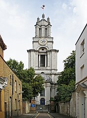
St Anne's Limehouse was formed from part of the parish of St. Dunstan's Stepney, prior to the 18th century a large (but then thinly populated) East London parish that extended all the way down to the Thames River. As the population of London increased, growing parishes were subdivided. In 1709 a new parish in Limehouse was formed from part of the parish of St. Dunstan. The church may be named for Queen Anne as she raised money for it by taxing coal passing along the River Thames. The building was designed by Nicholas Hawksmoor, as one of twelve churches built to serve the needs of the rapidly expanding population of London in the 18th century. The scheme never met its original target, but those built were also known as the Queen Anne Churches. The building was completed in 1727 and consecrated in 1730. Queen Anne decreed that as the new church was close to the river it would be a convenient place of registry for sea captains to register vital events taking place at sea. Therefore, she gave St. Anne's Church the right to display the second most senior ensign of the Royal Navy, the White Ensign. The prominent tower with its golden ball on the flagpole became a Trinity House "sea mark" on navigational charts, and the Queen's Regulations still permit St. Anne's Limehouse to display the White Ensign 24 hours a day, 365 days a year. Hawksmoor, who worked with Wren and Vanburgh, has been 'rediscovered' in recent years. His style is innovative and eclectic. Some have portrayed his churches as centres of gloom and mystery, full of occult and morbid energies and pagan symbols, linked to ancient lay lines and to murders in Whitechapel and on the notorious Ratcliffe Highway (which now links the City and Canary Wharf). |
| Kuupäev | |
| Allikas | St Anne, Limehouse |
| Autor | Amanda Slater from Coventry, West Midlands, UK |
| Kaamera asukoht | | See ja teised pildid sellest paigast lehel: OpenStreetMap |
|---|
.jpg¶ms=051.510311_N_-000.030169_E_globe:Earth_type:camera_source:Flickr_&language=et)
Litsents
- Tohid:
- jagada – teost kopeerida, levitada ja edastada
- kohandada – valmistada muudetud teoseid
- Järgmistel tingimustel:
- omistamine – Pead materjali sobival viisil autorile omistama, tooma ära litsentsi lingi ja märkima ära, kas on tehtud muudatusi. Sobib, kui teed seda mõistlikul viisil, kuid seejuures ei tohi jääda muljet, et litsentsiandja tõstab esile sind või seda, et sina materjali kasutad.
- sarnaselt jagamine – Kui töötled, kujundad ümber või arendad materjali edasi, siis pead oma töö levitamiseks kasutama sama litsentsi, mille all on algupärand, või ühilduvat litsentsi.
| amandabhslater postitas selle pildi algselt saidile Flickr. Robot FlickreviewR 2 vaatas selle pildi üle ja kinnitas, et see oli saadaval litsentsi cc-by-sa-2.0 all. Vaadatud: 17. november 2017 |
Faili ajalugu
Klõpsa kuupäeva ja kellaaega, et näha sel ajahetkel kasutusel olnud failiversiooni.
| Kuupäev/kellaaeg | Pisipilt | Mõõtmed | Kasutaja | Kommentaar | |
|---|---|---|---|---|---|
| viimane | 17. november 2017, kell 11:03 | | 2681 × 3648 (5,52 MB) | Ham II | Transferred from Flickr via Flickr2Commons |
Faili kasutus
Seda faili kasutab järgmine lehekülg:
Globaalne failikasutus
Järgmised muud vikid kasutavad seda faili:
- Faili kasutus vikis arz.wikipedia.org
- Faili kasutus vikis cs.wikipedia.org
- Faili kasutus vikis de.wikipedia.org
- Faili kasutus vikis de.wikivoyage.org
- Faili kasutus vikis en.wikipedia.org
- Faili kasutus vikis es.wikipedia.org
- Faili kasutus vikis it.wikipedia.org
- Faili kasutus vikis ru.wikipedia.org
- Faili kasutus vikis uk.wikipedia.org
- Faili kasutus vikis www.wikidata.org
.jpg)