Fail:RedArmy19Aug31Dec44.jpg
Selle eelvaate suurus: 788 × 600 pikslit. Teised eraldusvõimed: 315 × 240 pikslit | 631 × 480 pikslit | 1009 × 768 pikslit | 1256 × 956 pikslit.
Algfail (1256 × 956 pikslit, faili suurus: 531 KB, MIME tüüp: image/jpeg)
| See fail ja sellest kastist allapoole jääv kirjeldus pärinevad kesksest failivaramust Wikimedia Commons. | Faili lehekülg Commonsis |
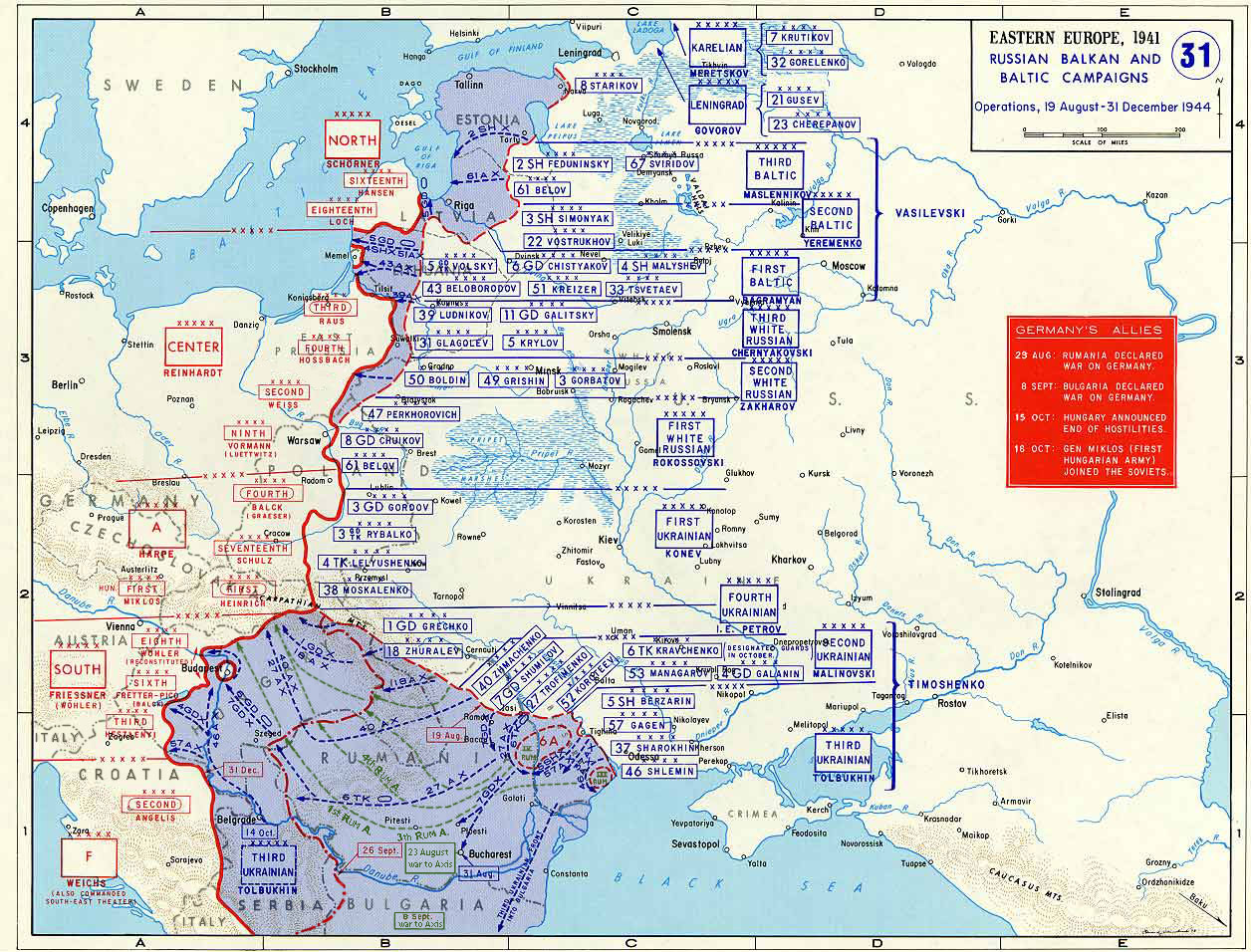
Taken from the campaign series, made public by the US-Army under www.dean.usma.edu The picture is public domain. It shows the situation of the Easter Front from 13. Aug. '44 until 31. Dec. '44
- Source: dean.usma.edu archive copy at the Wayback Machine
From website:
- In 1938 the predecessors of what is today The Department of History at the United States Military Academy began developing a series of campaign atlases to aid in teaching cadets a course entitled, "History of the Military Art." Since then, the Department has produced over six atlases and more than one thousand maps, encompassing not only America’s wars but global conflicts as well.
- In keeping abreast with today's technology, the Department of History is providing these maps on the internet as part of the department's outreach program. The maps were created by the United States Military Academy’s Department of History and are the digital versions from the atlases printed by the United States Defense Printing Agency. We gratefully acknowledge the accomplishments of the department's former cartographer, Mr. Edward J. Krasnoborski, along with the works of our present cartographer, Mr. Frank Martini.
- Please be aware that these maps are large in file size and may require substantial download times.
See pilt on Ameerika Ühendriikide maaväe sõduri või teenistuja tehtud või üles võetud ametikohustuste täitmise ajal. Ameerika Ühendriikide keskvalitsuse teosena kuulub see pilt avalikku omandisse.
|
 |

|
See pilt tuleks konverteerida kasutades vektorgraafikat (SVG-vorming). Vektorkujutisel on mitmeid eeliseid. Konverteerimise kohta vaata täpsemalt siit. Kui sellest pildist on vektorkujutis juba saadaval, siis pane selle malli asemele {{vector version available|uue pildi nimi.svg}}.
|


Faili ajalugu
Klõpsa kuupäeva ja kellaaega, et näha sel ajahetkel kasutusel olnud failiversiooni.
| Kuupäev/kellaaeg | Pisipilt | Mõõtmed | Kasutaja | Kommentaar | |
|---|---|---|---|---|---|
| viimane | 12. jaanuar 2015, kell 21:47 | | 1256 × 956 (531 KB) | Spiridon Ion Cepleanu | Borders of years 1940-1944 (rectified some little mistakes) |
| 22. aprill 2007, kell 13:52 |  | 1256 × 956 (203 KB) | Nasiruddin | Taken from the campaign series, made public by the US-Army under www.dean.usma.edu The picture is public domain. It shows the situation of the Easter Front from 13. Aug. '44 until 31. Dec. '44 *Source: [http://www.dean.usma.edu/history/web03/atlases/grea |
Faili kasutus
Seda faili kasutavad järgmised 4 lehekülge:
Globaalne failikasutus
Järgmised muud vikid kasutavad seda faili:
- Faili kasutus vikis ar.wikipedia.org
- Faili kasutus vikis ca.wikipedia.org
- Faili kasutus vikis cs.wikipedia.org
- Faili kasutus vikis de.wikipedia.org
- Faili kasutus vikis el.wikipedia.org
- Faili kasutus vikis en.wikipedia.org
- Faili kasutus vikis es.wikipedia.org
- Faili kasutus vikis fr.wikipedia.org
- Faili kasutus vikis he.wikipedia.org
- Faili kasutus vikis id.wikipedia.org
- Faili kasutus vikis it.wikipedia.org
- Faili kasutus vikis ja.wikipedia.org
- Faili kasutus vikis nl.wikipedia.org
- Faili kasutus vikis pl.wikipedia.org
- Faili kasutus vikis pnb.wikipedia.org
- Faili kasutus vikis ro.wikipedia.org
- Faili kasutus vikis ru.wikipedia.org
- Faili kasutus vikis sh.wikipedia.org
- Faili kasutus vikis sr.wikipedia.org
- Faili kasutus vikis tr.wikipedia.org
Vaata selle faili globaalset kasutust.