Fail:Napoleonic Wars War of the Sixth Coalition.png
Selle eelvaate suurus: 800 × 370 pikslit. Teised eraldusvõimed: 320 × 148 pikslit | 640 × 296 pikslit | 1357 × 628 pikslit.
Algfail (1357 × 628 pikslit, faili suurus: 34 KB, MIME tüüp: image/png)
| See fail ja sellest kastist allapoole jääv kirjeldus pärinevad kesksest failivaramust Wikimedia Commons. | Faili lehekülg Commonsis |
Lühikirjeldus
| Kirjeldus |
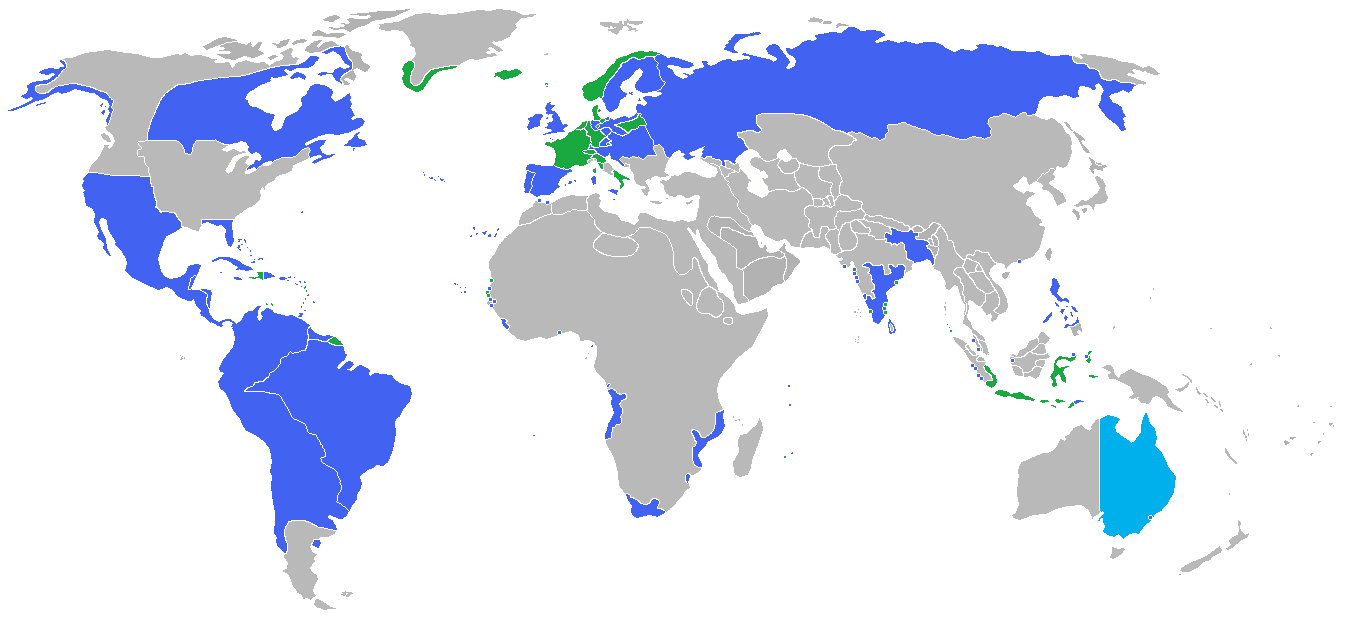
English: Locator map of the competing sides of the War of the Sixth Coalition of the Napoleonic Wars (1812-1814). Blue: Russian Empire, Prussia, Austrian Empire, Sweden, United Kingdom of Great Britain and Ireland, Spain, Portugal, Sicily, Sardinia, Saxony, Bavaria, Württemberg |
| Kuupäev | |
| Allikas | Üleslaadija oma töö |
| Autor | Gabagool |
Litsents
Autoriõiguse omanikuna avaldan selle teose järgmise litsentsi all:
See fail kuulub jurisdiktsiooniga sidumata Creative Commonsi litsentsi "Autorile viitamine 3.0" alla.
- Tohid:
- jagada – teost kopeerida, levitada ja edastada
- kohandada – valmistada muudetud teoseid
- Järgmistel tingimustel:
- omistamine – Pead materjali sobival viisil autorile omistama, tooma ära litsentsi lingi ja märkima ära, kas on tehtud muudatusi. Sobib, kui teed seda mõistlikul viisil, kuid seejuures ei tohi jääda muljet, et litsentsiandja tõstab esile sind või seda, et sina materjali kasutad.
Faili ajalugu
Klõpsa kuupäeva ja kellaaega, et näha sel ajahetkel kasutusel olnud failiversiooni.
| Kuupäev/kellaaeg | Pisipilt | Mõõtmed | Kasutaja | Kommentaar | |
|---|---|---|---|---|---|
| viimane | 5. juuli 2018, kell 05:15 | | 1357 × 628 (34 KB) | Themane2 | Louisiana border. |
| 18. oktoober 2009, kell 04:30 |  | 1357 × 628 (45 KB) | Historiographer~commonswiki | added Korean border | |
| 1. september 2009, kell 22:50 |  | 1357 × 628 (45 KB) | Gabagool | {{Information |Description={{en|1=Locator map of the competing sides of the War of the Sixth Coalition of the Napoleonic Wars (1812-1814).<br> <font color="Blue">Blue</font>: Russian Empire, Prussia, Austrian Empire, Sweden, United Kingdom of Great Britai |
Faili kasutus
Seda faili kasutab järgmine lehekülg: