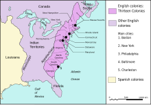
Fail:Map of territorial growth 1775.svg

Selle SVG-faili PNG-vormingus eelvaate suurus: 458 × 599 pikslit. Teised eraldusvõimed: 183 × 240 pikslit | 367 × 480 pikslit | 587 × 768 pikslit | 783 × 1024 pikslit | 1565 × 2048 pikslit | 506 × 662 pikslit.
Algfail (SVG-fail, algsuurus 506 × 662 pikslit, faili suurus: 507 KB)
Faili ajalugu
Klõpsa kuupäeva ja kellaaega, et näha sel ajahetkel kasutusel olnud failiversiooni.
| Kuupäev/kellaaeg | Pisipilt | Mõõtmed | Kasutaja | Kommentaar | |
|---|---|---|---|---|---|
| viimane | 3. märts 2023, kell 08:13 |  | 506 × 662 (507 KB) | Johnn Francis | Reverted to version as of 21:34, 7 January 2009 (UTC) This map describes the situation in the year 1775. Florida was acquired by Britain in 1763 from Spain (who would re-acquire it in 1783). Therefore Florida (both west and east) was British at the time this map is set. |
| 19. detsember 2022, kell 19:41 |  | 506 × 662 (503 KB) | PatriaDeTodos | Florida was Spanish between 1513 and 1821 | |
| 8. jaanuar 2009, kell 00:34 |  | 506 × 662 (507 KB) | Cg-realms | Fixed English text | |
| 8. jaanuar 2009, kell 00:18 |  | 506 × 662 (231 KB) | Cg-realms | {{Information |Description={{en|1=Map of territorial growth, 1775. Adapted to vector graphics from JPG scan.}} |Source=Adapted from National Atlas of the United States scan uploaded by Kooma |Aut |
Faili kasutus
Seda faili kasutab järgmine lehekülg:
Globaalne failikasutus
Järgmised muud vikid kasutavad seda faili:
- Faili kasutus vikis af.wikipedia.org
- Faili kasutus vikis als.wikipedia.org
- Faili kasutus vikis am.wikipedia.org
- Faili kasutus vikis ang.wikipedia.org
- Faili kasutus vikis ar.wikipedia.org
- Faili kasutus vikis arz.wikipedia.org
- Faili kasutus vikis ast.wikipedia.org
- Faili kasutus vikis azb.wikipedia.org
- Faili kasutus vikis be.wikipedia.org
- Faili kasutus vikis bg.wikipedia.org
- Faili kasutus vikis bh.wikipedia.org
- Faili kasutus vikis bn.wikipedia.org
- Faili kasutus vikis ca.wikipedia.org
- Guerra de la Independència dels Estats Units
- Tretze Colònies
- Batalles de Lexington i Concord
- Batalla de Pensacola
- Batalla de Fort Charlotte
- Batalla de Mobile
- Batalla de Yorktown (1781)
- Batalla de Saratoga
- Batalla de Bunker Hill
- Batalla de Baton Rouge (1779)
- Setge de Charleston
- Batalla de Brandywine
- Batalla de Germantown
- Batalla de Kings Mountain
- Batalla de Monmouth
- Batalla de Princeton
- Batalla de Trenton
- Batalla de Chesapeake
- Plantilla:Location map 13 Colònies
- Captura de Fort Bute
- Assimilació cultural dels amerindis dels Estats Units
- Indian Intercourse Act
- Teatre nord de la Guerra de la Revolució Americana després de Saratoga
- Teatre oest de la Guerra de la Revolució Americana
- Teatre sud de la Guerra de la Revolució Americana
- Campanya de Yorktown
- Operacions navals de la Guerra de la Revolució Americana
- Nova Escòcia a la Revolució Americana
Vaata selle faili globaalset kasutust.


