Fail:Map of Hven from copper etching of Blaeu Atlas 1663.jpg
Algfail (6304 × 4939 pikslit, faili suurus: 19,49 MB, MIME tüüp: image/jpeg)
| See fail ja sellest kastist allapoole jääv kirjeldus pärinevad kesksest failivaramust Wikimedia Commons. | Faili lehekülg Commonsis |
| Kirjeldus |
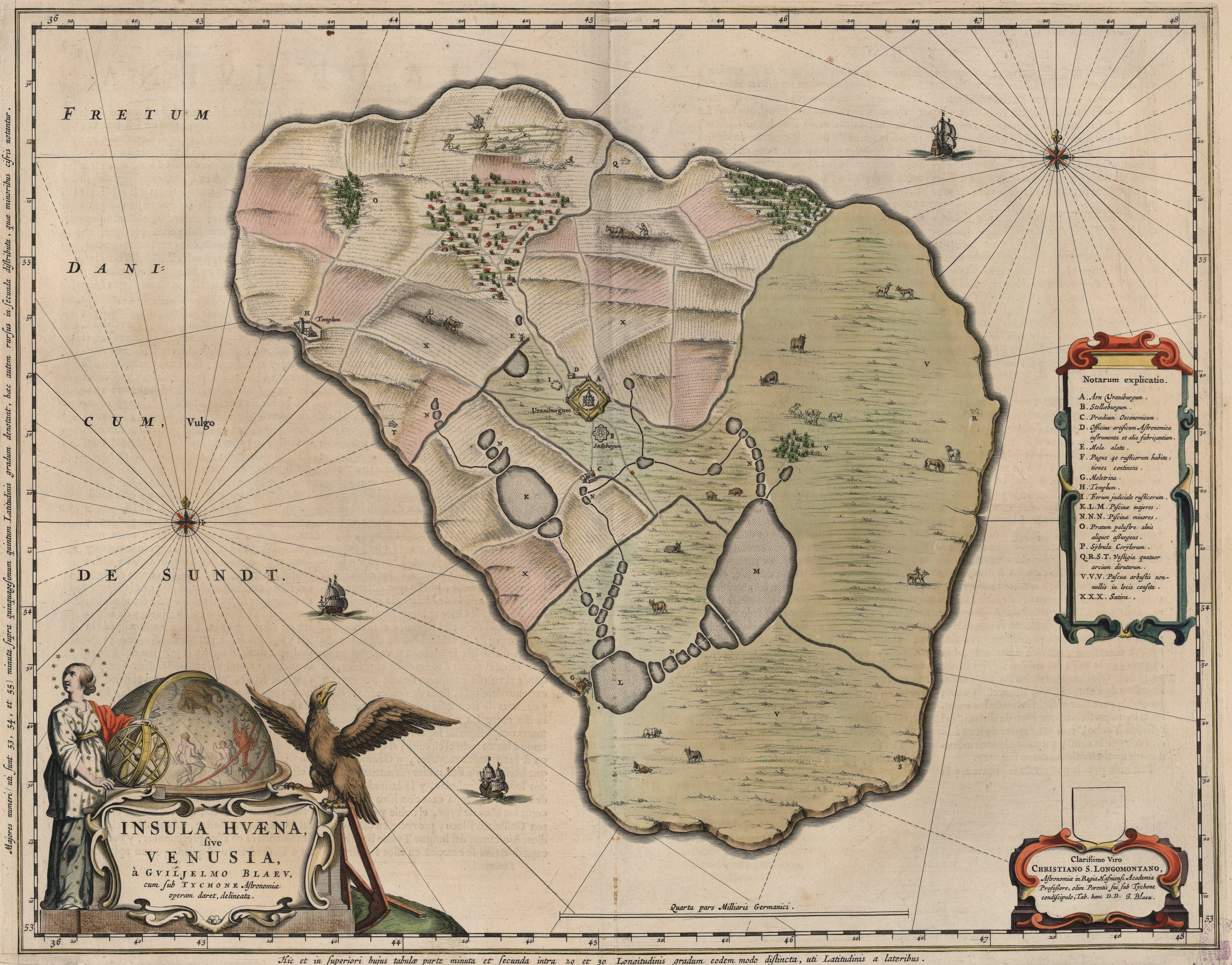
English: Map of the island of Hven from a copper etching of Willem Janszoon Blaeu's Blaeu Atlas 1663.
Willem made this map based on his experience as a student of Tycho Brahe between 1594 and 1596. On this map North is up, Denmark to the west and Scania, now part of Sweden, to the east. It shows the location of Uraniborg just above the centre, and below the linked set of ponds that Tycho had created to both collect water and power his papermill and other small industries on the island. Name of map : INSULAE HVAENA Map record source: Biblioteca Nacionale Espana (click on "View Digital object" to browse from the first page down to "GMG/189/177/mapa") (1664 is date of atlas on title page at "GMG/189/5/hg-ilustracionr") vorige upload: Tychobrahe.com
|
||||||||||||||||||||||||||
| Kuupäev | |||||||||||||||||||||||||||
| Allikas | (There is no permanent link) Browse to [1], click "View Digital Object", scroll down and click on link "GMG/189/177/mapa", image should appear named "GMG189177mapa.jpeg" in right hand panel. | ||||||||||||||||||||||||||
| Autor |
|
||||||||||||||||||||||||||
.jpg)
|
See teos kuulub avalikku omandisse päritoluriigis ja teistes riikides, kus autoriõigus kehtib 100 aastat pärast autori surma või vähem. | |
| Seda faili peetakse autoriõigusseadusest ning kõigist seonduvatest ja ligidastest õigustest tulenevalt teadaolevatest piirangutest vabaks. | |
| Annotations | This image is annotated: View the annotations at Commons |


Faili ajalugu
Klõpsa kuupäeva ja kellaaega, et näha sel ajahetkel kasutusel olnud failiversiooni.
| Kuupäev/kellaaeg | Pisipilt | Mõõtmed | Kasutaja | Kommentaar | |
|---|---|---|---|---|---|
| viimane | 9. august 2016, kell 04:06 | | 6304 × 4939 (19,49 MB) | Centpacrr | crp |
| 4. jaanuar 2013, kell 14:46 |  | 7598 × 6341 (5,28 MB) | Joop Rotte | ietwat hogere resolutie | |
| 30. detsember 2005, kell 21:18 |  | 750 × 601 (89 KB) | Fred J | :: '' Originally uploaded on English Wikipedia by en:User:Wikibob. Map of the island of Hven from a copper etching of Willem Janszoon Blaeu's Blaeu Atlas 1663. Willem made this map while a student of Tycho Brahe between 1594 and 1596. On th |
Faili kasutus
Seda faili kasutab järgmine lehekülg:
Globaalne failikasutus
Järgmised muud vikid kasutavad seda faili:
- Faili kasutus vikis de.wikipedia.org
- Faili kasutus vikis en.wikipedia.org
- Faili kasutus vikis fa.wikipedia.org
- Faili kasutus vikis fr.wikipedia.org
- Faili kasutus vikis ia.wikipedia.org
- Faili kasutus vikis ja.wikipedia.org
- Faili kasutus vikis ko.wikipedia.org
- Faili kasutus vikis la.wikipedia.org
- Faili kasutus vikis mk.wikipedia.org
- Faili kasutus vikis nl.wikipedia.org
- Faili kasutus vikis pl.wikipedia.org
- Faili kasutus vikis ru.wikipedia.org
- Faili kasutus vikis sv.wikipedia.org
- Faili kasutus vikis uk.wikipedia.org
- Faili kasutus vikis zh.wikipedia.org