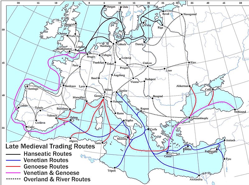
Fail:Late Medieval Trade Routes.jpg

Selle eelvaate suurus: 800 × 597 pikslit. Teised eraldusvõimed: 320 × 239 pikslit | 640 × 478 pikslit | 1024 × 765 pikslit | 1280 × 956 pikslit | 1457 × 1088 pikslit.
Algfail (1457 × 1088 pikslit, faili suurus: 372 KB, MIME tüüp: image/jpeg)
Faili ajalugu
Klõpsa kuupäeva ja kellaaega, et näha sel ajahetkel kasutusel olnud failiversiooni.
| Kuupäev/kellaaeg | Pisipilt | Mõõtmed | Kasutaja | Kommentaar | |
|---|---|---|---|---|---|
| viimane | 18. mai 2022, kell 23:46 |  | 1457 × 1088 (372 KB) | Richard2s | Clearer key for map |
| 23. jaanuar 2011, kell 23:25 |  | 853 × 544 (453 KB) | Micsha~commonswiki | Includes map key on the map | |
| 28. märts 2008, kell 18:55 |  | 1817 × 1120 (487 KB) | Lampman | {{Information |Description=Map showing the main trade routes of late medieval Europe. The black lines show the routes of the Hanseatic League, the blue Venetian and the red Genoese routes. Purple lines are routes used by both the Venetians and the Genoese |
Faili kasutus
Seda faili kasutavad järgmised 3 lehekülge:
Globaalne failikasutus
Järgmised muud vikid kasutavad seda faili:
- Faili kasutus vikis ar.wikipedia.org
- Faili kasutus vikis be-tarask.wikipedia.org
- Faili kasutus vikis bg.wikipedia.org
- Faili kasutus vikis ca.wikipedia.org
- Faili kasutus vikis da.wikipedia.org
- Faili kasutus vikis el.wikipedia.org
- Faili kasutus vikis en.wikipedia.org
- Faili kasutus vikis es.wikipedia.org
- Faili kasutus vikis fr.wikipedia.org
- Faili kasutus vikis he.wikipedia.org
- Faili kasutus vikis hy.wikipedia.org
- Faili kasutus vikis it.wikipedia.org
- Faili kasutus vikis ja.wikipedia.org
- Faili kasutus vikis mk.wikipedia.org
- Faili kasutus vikis nl.wikipedia.org
- Faili kasutus vikis pl.wikipedia.org
- Faili kasutus vikis pt.wikipedia.org
- Faili kasutus vikis rm.wikipedia.org
- Faili kasutus vikis sh.wikipedia.org
- Faili kasutus vikis sl.wikipedia.org
- Faili kasutus vikis sq.wikipedia.org
- Faili kasutus vikis uk.wikipedia.org
- Faili kasutus vikis vi.wikipedia.org
- Faili kasutus vikis www.wikidata.org

