Fail:KatrinaNewOrleansFlooded.jpg
Algfail (1153 × 1514 pikslit, faili suurus: 815 KB, MIME tüüp: image/jpeg)
| See fail ja sellest kastist allapoole jääv kirjeldus pärinevad kesksest failivaramust Wikimedia Commons. | Faili lehekülg Commonsis |
Lühikirjeldus
| Kirjeldus |
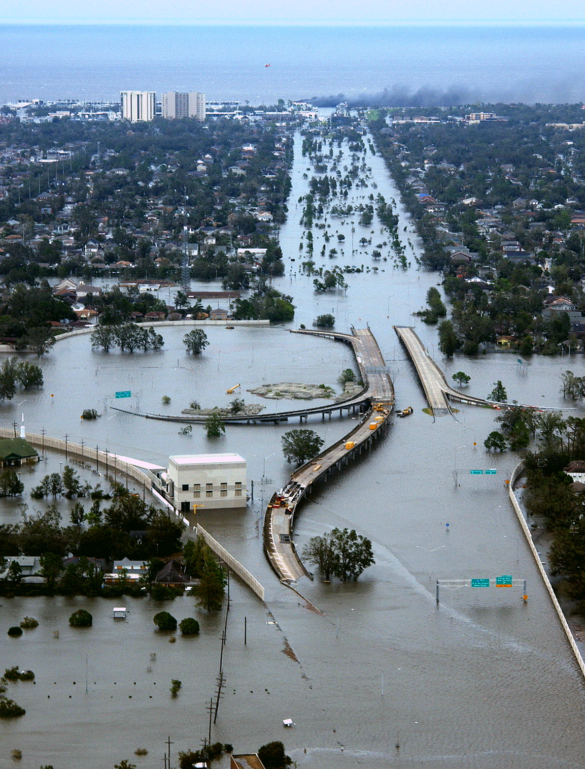
New Orleans, Louisiana in the aftermath of Hurricane Katrina (2005:08:29 17:24:22), showing Interstate 10 at West End Boulevard, looking towards Lake Pontchartrain. The 17th Street Canal is just beyond the left edge of the image. The breach in the levee of that canal was responsible for much of the flooding of the city in the hours after the hurricane. In the foreground, the intersection is the juncture of I-10, running from the bottom of the photo and curving out of the photo to the left, with the western end of I-610, which extends off the photo from the center right, and the West End entrance/exit from I-10. The block shaped building at center right front is a pumping station, one of those used to pump water from heavy rains off city streets in more normal times. The far eastern end of Veterans Memorial Boulevard is seen just back from the interchange extending to the left. The view looks north toward Lake Pontchartrain. The stretch of ground with no buildings from the Interchange to the lake is Pontchartrain Blvd. (on the left) and West End Blvd. (on the right), with a linear park (formerly the route of the New Basin Canal) between them. Smoke can be seen rising near the lake, probably from the burning of the Southern Yacht Club building. This photo provided by the U.S. Coast Guard shows flooded roadways as the Coast Guard conducted initial Hurricane Katrina damage assessment overflights of New Orleans, Monday Aug. 29, 2005. Deutsch: Das überflutete New Orleans
Español: La ciudad de Nueva Orleans, después del paso del Katrina. El foto aqui muestra la carretera 10 despues del huracan.
Suomi: 80% New Orleansista jäi veden alle, kun hurrikaani Katrina iski Yhdysvaltain rannikolle elokuussa 2005 |
|||
| Kuupäev | ||||
| Allikas | Published here and here | |||
| Autor | AP Photo/U.S. Coast Guard, Petty Officer 2nd Class Kyle Niemi | |||
| Luba (Faili edasikasutus) |
|
|||
| Teised versioonid |
 |

Faili ajalugu
Klõpsa kuupäeva ja kellaaega, et näha sel ajahetkel kasutusel olnud failiversiooni.
| Kuupäev/kellaaeg | Pisipilt | Mõõtmed | Kasutaja | Kommentaar | |
|---|---|---|---|---|---|
| viimane | 3. veebruar 2006, kell 05:04 | | 1153 × 1514 (815 KB) | Jdorje~commonswiki | |
| 6. september 2005, kell 07:53 |  | 1199 × 1555 (685 KB) | Elya | Reverted to earlier revision | |
| 1. september 2005, kell 06:26 |  | 1199 × 1555 (685 KB) | Chiacomo | New Orleans, Louisiana in the aftermath of Hurricane Katrina (2005:08:29 17:24:22), showing Interstate 10 at West End Boulevard, looking towards Lake Pontchartrain. The 17th Street Canal is just beyond the left edge of the image. The breach in the levee o |
Faili kasutus
Seda faili kasutavad järgmised 2 lehekülge:
Globaalne failikasutus
Järgmised muud vikid kasutavad seda faili:
- Faili kasutus vikis af.wikipedia.org
- Faili kasutus vikis ar.wikipedia.org
- Faili kasutus vikis br.wikipedia.org
- Faili kasutus vikis ca.wikipedia.org
- Faili kasutus vikis cs.wikipedia.org
- Faili kasutus vikis da.wikipedia.org
- Faili kasutus vikis de.wikipedia.org
- Faili kasutus vikis de.wikinews.org
- Faili kasutus vikis de.wikiversity.org
- Faili kasutus vikis en.wikipedia.org
- User:Dscos/imagelist
- User:Spikebrennan
- User:E. Brown/Track Model Test Area
- User:Hmich176/Userboxes
- Wikipedia talk:WikiProject Userboxes/Ideas/Archive 2
- User:ChristinaRich
- Wikipedia:Featured picture candidates/June-2007
- Wikipedia:Featured picture candidates/KatrinaNewOrleansFlooded.jpg
- User:E. Brown/Hurricane Hall of Fame, continued
- Faili kasutus vikis en.wikibooks.org
- Faili kasutus vikis en.wikinews.org
- Faili kasutus vikis eo.wikipedia.org
- Faili kasutus vikis es.wikipedia.org
- Faili kasutus vikis es.wikinews.org
- Faili kasutus vikis fi.wikipedia.org
- Faili kasutus vikis fo.wikipedia.org
- Faili kasutus vikis fr.wikipedia.org
- Faili kasutus vikis hy.wikipedia.org
- Faili kasutus vikis io.wikipedia.org
- Faili kasutus vikis it.wikipedia.org
- Faili kasutus vikis ja.wikipedia.org
- Faili kasutus vikis ja.wikinews.org
- Faili kasutus vikis nl.wikinews.org
- Faili kasutus vikis nn.wikipedia.org
Vaata selle faili globaalset kasutust.