Fail:Indo-European branches map.png

Algfail (2934 × 2938 pikslit, faili suurus: 2,16 MB, MIME tüüp: image/png)
| See fail ja sellest kastist allapoole jääv kirjeldus pärinevad kesksest failivaramust Wikimedia Commons. | Faili lehekülg Commonsis |

|
Vektorkujutis (SVG) sellest pildist on saadaval. Kui SVG-pilt paremat kvaliteeti võimaldab, tuleks seda rasterkujutise asemel kasutada.
File:Indo-European branches map.png → File:Indo-European branches map.svg
|
 |
Lühikirjeldus
| Kirjeldus |
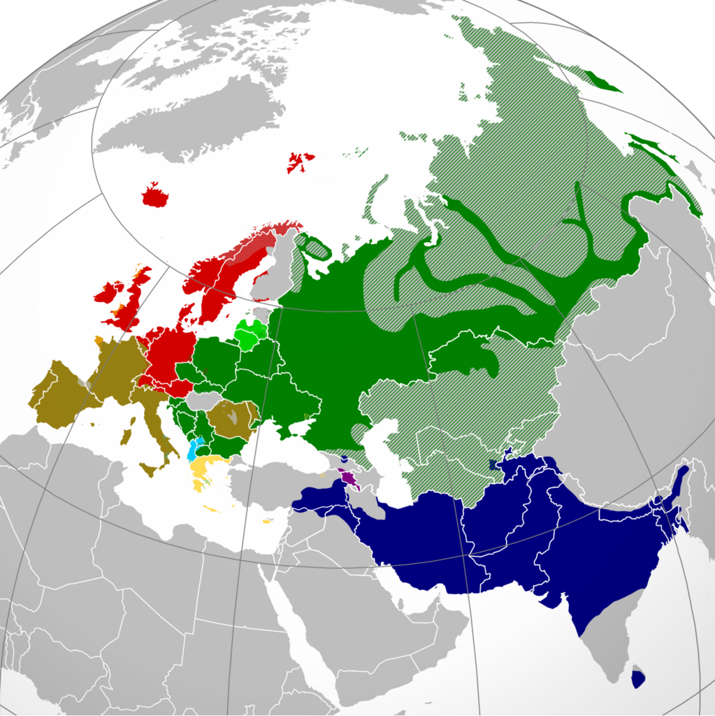
English: A map showing the approximate present-day distribution of the Indo-European branches within their homelands of Europe and Asia. The following legend is given in the chronological order of the earliest surviving written attestations of each branch:
Non-Indo-European languages
Dotted/striped areas indicate where multilingualism is common (more visible upon full enlargement of the map). |
||
| Kuupäev | |||
| Allikas |
For the names of the branches, see citations in legend (based on "Indo-European Languages". The College of Liberal Arts. UT Austin. 2008.) and "Indo-European languages" from Britannica.com. The distribution is essentially and approximately based on the map "Indo-European languages – Approximate locations of Indo-European languages in contemporary Eurasia" from Britannica.com, although with the following minor modifications: The two articles "Balto-Slavic languages" and "Indo-Iranian languages" from Britannica.com stress the lack of scholarly consensus on these branches. That is, for the former, whether Baltic and Slavic developed from a common ancestral language, or that the similarities are the result of parallel development and of mutual influence during a long period of contact. To cater for both scholarly viewpoints, this map shows Baltic and Slavic with two distinct shades of green under "Balto-Slavic". For the latter, the dispute is whether the Indo-Iranian languages include just the Iranian and Indo-Aryan (or, Indic) language groups, or Nūristānī and Bangani too. To prevent disagreement (and also because this map only represents the primary branches of Indo-European), all of Indo-Iranian is represented with one shade. The article "Romance languages" from Britannica.com states that the Romance languages form "a subgroup of the Italic branch of the Indo-European language family". It should be noted that this map is only approximative and simplified, and glosses over some multilingual areas (particularly in eastern Russia, which is difficult to represent accurately). For some areas, more regional maps have been used as sources for greater accuracy, namely "Languages of Switzerland" from Ethnologue.com, "Russia ethnic plurality" from Freelang.net, "Major ethnic groups in Central Asia" from Globalsecurity.org, and "South Asian Language Families" from "Language families and branches, languages and dialects in A Historical Atlas of South Asia". Oxford University Press. New York 1992. |
||
| Autor | Hayden120 | ||
| Luba (Faili edasikasutus) |
Autoriõiguse omanikuna avaldan selle teose järgmiste litsentside all: See fail kuulub Creative Commonsi jurisdiktsiooniga sidumata litsentsi "Autorile viitamine + jagamine samadel tingimustel 3.0" ning üldise litsentsi "Autorile viitamine + jagamine samadel tingimustel" versioonide 2.5, 2.0 ja 1.0 alla.
Sa võid valida endale sobiva litsentsi. |

Faili ajalugu
Klõpsa kuupäeva ja kellaaega, et näha sel ajahetkel kasutusel olnud failiversiooni.
| Kuupäev/kellaaeg | Pisipilt | Mõõtmed | Kasutaja | Kommentaar | |
|---|---|---|---|---|---|
| viimane | 26. september 2022, kell 06:43 | | 2934 × 2938 (2,16 MB) | Alexikoua | minor fixes |
| 30. märts 2022, kell 18:58 |  | 2934 × 2938 (1,74 MB) | Whoop whoop pull up | Whoops, wrong file! | |
| 30. märts 2022, kell 18:37 |  | 2048 × 2048 (980 KB) | Whoop whoop pull up | Misc fixes (Russian minority in Svalbard & Israel, Slovenian in SE Carinthia, Greek in N Epirus, Aromanians/Megleno-Romanians, Swedish essentially extinct in Estonia, etc. | |
| 22. detsember 2021, kell 12:37 |  | 2934 × 2938 (1,74 MB) | Ahmet Q. | Reverted to version as of 19:55, 23 August 2021 (UTC)seek consensus for your changes | |
| 25. november 2021, kell 23:40 |  | 2934 × 2938 (2,16 MB) | Alexikoua | rv elimination of Greek minority in Albania | |
| 23. august 2021, kell 22:55 |  | 2934 × 2938 (1,74 MB) | Ahmet Q. | Rv false edit summary. Overrepresentation of Greeks in Turkey, Albania and Ukraine. Unexplained removal of Romanian in Serbia. Overall deterioration of the original file. Seek consensus for your changes. | |
| 7. august 2021, kell 19:16 |  | 2934 × 2938 (2,16 MB) | Demetrios1993 | Addition of Arbereshe linguistic minority in Sicily. Addition of Serbian, Bosnian, and Gorani linguistic minorities in Kosovo. Addition of Greek linguistic minorities in Italy, Albania, Turkey, and Ukraine. Including some other minor corrections. | |
| 19. november 2020, kell 20:00 |  | 2934 × 2938 (1,74 MB) | Golden | update Armenian | |
| 31. märts 2018, kell 21:42 |  | 1479 × 1479 (574 KB) | Maphobbyist | Removed area that exactly corresponds to the non-Indo European Lezgi linguistic area. | |
| 7. september 2016, kell 00:37 |  | 1479 × 1479 (620 KB) | Rob984 | Georgia and Azerbaijan aren't majority multilingual. Older generations speak Russian from the Soviet era but now English is taught mainly in place of Russian. More people speak English in Finland, yet that isn't coloured. Also corrections to Celtic are... |
Faili kasutus
Seda faili kasutab järgmine lehekülg:
Globaalne failikasutus
Järgmised muud vikid kasutavad seda faili:
- Faili kasutus vikis ast.wikipedia.org
- Faili kasutus vikis ban.wikipedia.org
- Faili kasutus vikis be-tarask.wikipedia.org
- Faili kasutus vikis be.wikipedia.org
- Faili kasutus vikis bg.wikipedia.org
- Faili kasutus vikis cs.wikipedia.org
- Faili kasutus vikis da.wikipedia.org
- Faili kasutus vikis de.wikipedia.org
- Faili kasutus vikis en.wikipedia.org
- Faili kasutus vikis en.wikiversity.org
- Faili kasutus vikis es.wikipedia.org
- Faili kasutus vikis eu.wikipedia.org
- Faili kasutus vikis fa.wikipedia.org
- Faili kasutus vikis fi.wikipedia.org
- Faili kasutus vikis frr.wikipedia.org
- Faili kasutus vikis fr.wikipedia.org
- Faili kasutus vikis gl.wikipedia.org
- Faili kasutus vikis gu.wikipedia.org
- Faili kasutus vikis gv.wikipedia.org
- Faili kasutus vikis hak.wikipedia.org
- Faili kasutus vikis he.wikipedia.org
- Faili kasutus vikis hy.wikipedia.org
- Faili kasutus vikis hyw.wikipedia.org
- Faili kasutus vikis ilo.wikipedia.org
- Faili kasutus vikis incubator.wikimedia.org
- Faili kasutus vikis io.wikipedia.org
- Faili kasutus vikis it.wikipedia.org
Vaata selle faili globaalset kasutust.