Fail:Hammurabi's Babylonia Locator Map 1.svg

Selle SVG-faili PNG-vormingus eelvaate suurus: 671 × 600 pikslit. Teised eraldusvõimed: 269 × 240 pikslit | 537 × 480 pikslit | 859 × 768 pikslit | 1146 × 1024 pikslit | 2291 × 2048 pikslit | 744 × 665 pikslit.
Algfail (SVG-fail, algsuurus 744 × 665 pikslit, faili suurus: 154 KB)
| See fail ja sellest kastist allapoole jääv kirjeldus pärinevad kesksest failivaramust Wikimedia Commons. | Faili lehekülg Commonsis |
Lühikirjeldus
| Kirjeldus |
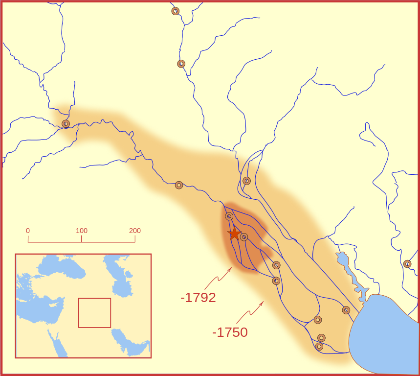
A locator map of Hammurabi's Babylonia, showing the Babylonian territory upon his ascension in 1792 BC and upon his death in 1750 BC. The river courses and coastline are those of that time period -- in general, they are not the modern rivers or coastlines. This is a Mercator projection, with north in its usual position. There is some question to what degree the cities of Nineveh, Tuttul, and Assur were under Babylonian authority. While in his introduction to his code of laws, Hammurabi claims lordship over these cities, Roaf does not include any of these in his map, upon which this map is based, and Chevalas states that "Assur and Nineveh were held for a very few years" (p. 155). Therefore, I have not included them as under Hammurabi's control in 1750 BC. |
| Kuupäev | |
| Allikas | Üleslaadija oma töö |
| Autor | MapMaster |
| Teised versioonid |
[]
|


Other versions
References
- Bjorklund, Oddvar; Holmboe, Haakon; Rohr, Anders (1970) Historical Atlas of the World, Barnes & Noble, NY, SBN: 389-00253-4.
- Chavalas, Mark W.; K. Lawson Younger (2003) Mesopotamia and the Bible, Continuum International Publishing Group, ISBN 978-0567082312.
- Hammond World Atlas Corporation (2007) Historical World Atlas, ISBN 9-780843-71391-6
- Roaf, M. (1990) Cultural Atlas of Mesopotamia and the ancient Near East, Oxford: Facts on File. (In general, the basis for the ancient river courses and ancient coastline).
- Van De Mieroop, Marc (2005). King Hammurabi of Babylon: A Biography. Blackwell Publishing. ISBN 1405126604
Litsents
Autoriõiguse omanikuna avaldan selle teose järgmiste litsentside all:

|
Luba on antud selle dokumendi kopeerimiseks, avaldamiseks ja/või muutmiseks GNU Vaba Dokumentatsiooni Litsentsi versiooni 1.2 või hilisema Vaba Tarkvara Fondi avaldatud versiooni tingimuste alusel; muutumatute osadeta, esikaane tekstideta ja tagakaane tekstideta. Sellest loast on lisatud koopia leheküljel pealkirjaga "GNU Free Documentation License". |
This file is licensed under the Creative Commons Attribution-Share Alike 4.0 International, 3.0 Unported, 2.5 Generic, 2.0 Generic and 1.0 Generic license.
- Tohid:
- jagada – teost kopeerida, levitada ja edastada
- kohandada – valmistada muudetud teoseid
- Järgmistel tingimustel:
- omistamine – Pead materjali sobival viisil autorile omistama, tooma ära litsentsi lingi ja märkima ära, kas on tehtud muudatusi. Sobib, kui teed seda mõistlikul viisil, kuid seejuures ei tohi jääda muljet, et litsentsiandja tõstab esile sind või seda, et sina materjali kasutad.
- sarnaselt jagamine – Kui töötled, kujundad ümber või arendad materjali edasi, siis pead oma töö levitamiseks kasutama sama litsentsi, mille all on algupärand, või ühilduvat litsentsi.
Sa võid valida endale sobiva litsentsi.
Faili ajalugu
Klõpsa kuupäeva ja kellaaega, et näha sel ajahetkel kasutusel olnud failiversiooni.
| Kuupäev/kellaaeg | Pisipilt | Mõõtmed | Kasutaja | Kommentaar | |
|---|---|---|---|---|---|
| viimane | 21. veebruar 2008, kell 06:26 | | 744 × 665 (154 KB) | MapMaster | "blurred" the territory outlines |
| 21. veebruar 2008, kell 02:22 |  | 744 × 665 (149 KB) | MapMaster | Changes based on a review of ''Mesopotamia and the Bible'' | |
| 21. veebruar 2008, kell 01:10 |  | 744 × 665 (151 KB) | MapMaster | Minor edits | |
| 19. veebruar 2008, kell 06:03 |  | 744 × 665 (150 KB) | MapMaster | Once more, with feeling | |
| 19. veebruar 2008, kell 05:09 |  | 744 × 665 (151 KB) | MapMaster | earlier upload would not render | |
| 19. veebruar 2008, kell 05:01 |  | 332 × 292 (333 KB) | MapMaster | {{Information |Description=A locator map of Hammurabi's Babylonia, showing the Babylonian territory upon his ascension in 1792 BC and upon his death in 1750 BC. The river courses and coastline are those of that time period -- in general, they are not the |
Faili kasutus
Seda faili kasutab järgmine lehekülg:
Globaalne failikasutus
Järgmised muud vikid kasutavad seda faili:
- Faili kasutus vikis bg.wikipedia.org
- Faili kasutus vikis bs.wikipedia.org
- Faili kasutus vikis cs.wikipedia.org
- Faili kasutus vikis da.wikipedia.org
- Faili kasutus vikis el.wikipedia.org
- Faili kasutus vikis eo.wikipedia.org
- Faili kasutus vikis fi.wikipedia.org
- Faili kasutus vikis fr.wikipedia.org
- Faili kasutus vikis gl.wikipedia.org
- Faili kasutus vikis he.wikipedia.org
- Faili kasutus vikis hr.wikipedia.org
- Faili kasutus vikis hu.wikipedia.org
- Faili kasutus vikis id.wikipedia.org
- Faili kasutus vikis it.wikipedia.org
- Faili kasutus vikis ja.wikipedia.org
- Faili kasutus vikis jv.wikipedia.org
- Faili kasutus vikis lt.wikipedia.org
- Faili kasutus vikis lv.wikipedia.org
- Faili kasutus vikis nl.wikipedia.org
- Faili kasutus vikis no.wikipedia.org
- Faili kasutus vikis pl.wikipedia.org
- Faili kasutus vikis pt.wikipedia.org
- Faili kasutus vikis ro.wikipedia.org
- Faili kasutus vikis ru.wikipedia.org
- Faili kasutus vikis sh.wikipedia.org
- Faili kasutus vikis sl.wikipedia.org
- Faili kasutus vikis sq.wikipedia.org
- Faili kasutus vikis sv.wikipedia.org
- Faili kasutus vikis sw.wikipedia.org
- Faili kasutus vikis tr.wikipedia.org