Algfail(1920 × 1440 pikslit, faili suurus: 1,41 MB, MIME tüüp: image/jpeg)

Lühikirjeldus

Kirjeldus
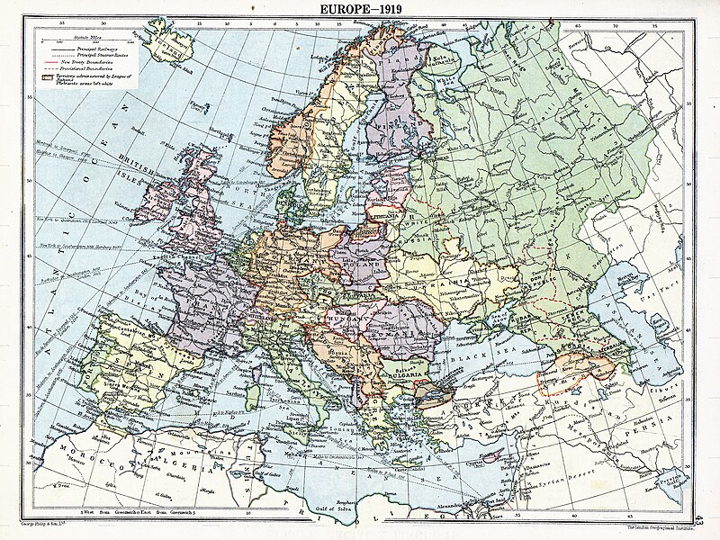
English: Map of en:Europe political divisions in 1919 (after the treaties of Brest-Litovsk and Versailles and before the treaties of Trianon, Riga, Kars and the establishment of en:Soviet Union and the republics of Ireland and Turkey) published by London Geographical Institute. This uploaded map is a photoshopped version of the original image located at hipkiss.org. According to the site, there are no copyrights to this map.
Allikas
Autor
Teised versioonid Derivative works of this file:  Europe map 1919 cropped.JPG
Maps of the history of Europe
BCE
aC

Weichselian ice age (c. 113,000–9700) · Neolithic expansion (c. 7000–4500) · Middle Neolithic (c. 4500–4000) · Late Neolithic (c. 4000–3000) · Copper Age – Corded Ware culture (c. 2900–2350) · Copper Age – Bellbeaker culture (c. 2800–1800) · Early Bronze Age – Unetice culture (c. 2300–1600) · Late Bronze Age – Urnfield culture (c. 1300—750) · Migrations (c. 1000–100) · Hallstatt & La Tène cultures (c. 800–100) · Roman Republic (510–40) · 220 · 218 · 200 · 201–100 · 58 · 49 · 39 · 30 BCE–6 CE


CE
dC

14 · 14–37 · 60 · 60 · 69 · 80 · Migrations 100–500 · 117 · 117 · 125 · Migrations 150–774 · Economy 180 · 271 · 293–305 · 337 · 395 · c. 395 · 400 · 400 · 450 · 457–61 · 476 · 480 · Franks 481–814 · Early Slavs 500–700 · 500 · 526 · 526–600 · Christianisation to 600 · c. 550 · 650 · Pontic Steppe 650 · 665 · 800 · Vikings 800–1050 · 814 · 843–70 · 850 · 900 · 912 · 998 · 1000 · 1000 · 1054 · 1092 · First Crusade 1095–99 · 1097 · 1135 · 1142 · 1147–49 · 1190 · 1190 · 1250 · c. 1250 · 1301-1400 · 1301-1400 · 1328 · 1345 · Black Plague 1347–51 · 1360 · 1400 · Trade routes c. 1400 · 1430 · 1470 · 1490 · 1492 · 1500 · 1519 · 1550 · 1560 · Religion 1560 · Religion 1600 · Religion 1618 · 1618–48 · 1648 · 1683 · 1700 · 1701 · 1708 · 1714 · 1721 · 1725–30 · 1739–1740 · 1740 · 1748–66 · 1783–1792 · 1787 · 1787 · 1789 · 1799 · 1812 · 1812 · 1812 · 1812 · 1813 · 1815 · 1815 · 1815 · 1818 · Ottoman Empire 1830–1923 · 1848–49 · 1861 · 1867 · 1871 · 1878 · 1890 · 1905 · 1911 · 1914 · 1914 · 1919 · 1919–29 · 1923 · 1929 · 1930 · 1940 · 1941–42 · 1942–45 · Cold War 1947–91 · 1950 · 1993–2006 · 2006 to date

(this template: · view · discuss )

Litsents

Public domain
Public domain
See teos on Ameerika Ühendriikides avalikus omandis. See käib Ameerika Ühendriikide teoste kohta, mille autoriõigus on aegunud. Põhjuseks võib olla teose avaldamine enne 1. jaanuari 1929. aastal. Täpsema teabe leiad sellelt leheküljelt.

United States
United States
Väljaspool Ameerika Ühendriike ei pruugi see pilt avalikus omandis olla (eriti riikides, nagu Hiina (välja arvatud Hongkong ja Aomen), Kanada, Mehhiko, Saksamaa ja Šveits, kus Ameerika Ühendriikide teostele ei kohaldu lühem autoriõiguse kehtivus). Autor ja avaldamisaasta peavad pildi juures märgitud olema. Täiendava teabe jaoks vaata lehekülgi Wikipedia:Public domain ja Wikipedia:Copyrights.

Esialgne üleslaadimislogi

Esialgne kirjelduslehekülg oli siin. Kõik järgmised kasutajanimed viitavad projektile en.wikipedia.
  • 2007-11-03 20:09 MaGioZal 1996×1506×8 (1457003 bytes) Map of [[Europe]] political divisions in 1919 (after the treaties of [[Treaty_of_Brest-Litovsk|Brest-Livotsk]] and [[Treaty of Versailles|Versailles]] and before the [[Treaty of Riga]] and the creation of [[Soviet Union]]) published by London Geographical

Pealdised

Lisa üherealine seletus sellest, mida fail esitab
The situation in Europe after WW1. Several new states were born such as Ukraine(the country in Yellow at the North of the Black Sea)

Selles failis kujutatud üksused

kujutab

MIME type inglise

image/jpeg

Faili ajalugu

Klõpsa kuupäeva ja kellaaega, et näha sel ajahetkel kasutusel olnud failiversiooni.

Kuupäev/kellaaegPisipiltMõõtmedKasutajaKommentaar
viimane7. august 2023, kell 08:41Pisipilt versioonist seisuga 7. august 2023, kell 08:411920 × 1440 (1,41 MB)User-duckCropped to reduce border using CropTool with lossless mode.
23. aprill 2008, kell 02:29Pisipilt versioonist seisuga 23. aprill 2008, kell 02:291996 × 1506 (1,39 MB)File Upload Bot (Magnus Manske) {{BotMoveToCommons|en.wikipedia}} {{Information |Description={{en|Map of en:Europe political divisions in 1919 (after the treaties of Brest-Livotsk and Versailles and before the treaties o

Seda faili kasutavad järgmised 2 lehekülge:

Globaalne failikasutus

Järgmised muud vikid kasutavad seda faili:

Vaata selle faili globaalset kasutust.