Fail:Europe 1911.jpg

Selle eelvaate suurus: 731 × 600 pikslit. Teised eraldusvõimed: 293 × 240 pikslit | 585 × 480 pikslit | 936 × 768 pikslit | 1248 × 1024 pikslit | 2243 × 1840 pikslit.
Algfail (2243 × 1840 pikslit, faili suurus: 1,88 MB, MIME tüüp: image/jpeg)
| See fail ja sellest kastist allapoole jääv kirjeldus pärinevad kesksest failivaramust Wikimedia Commons. | Faili lehekülg Commonsis |
Lühikirjeldus
| Kirjeldus |
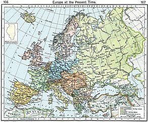
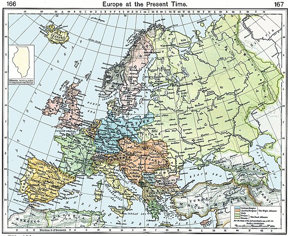
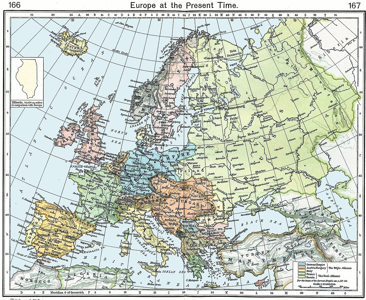
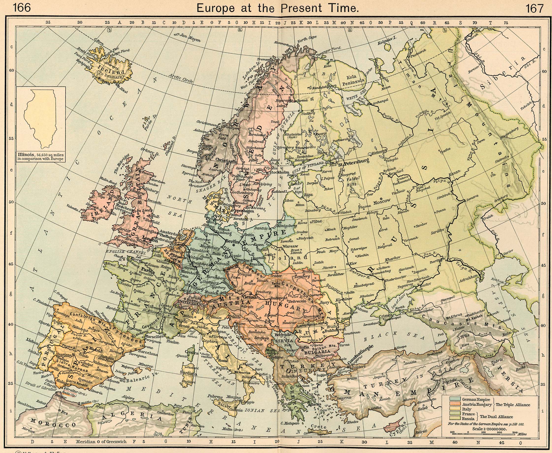
English: Europe in 1911 |
||||||||||||||||||||||
| Kuupäev | |||||||||||||||||||||||
| Allikas |
http://www.lib.utexas.edu/maps/historical/shepherd/europe_1911.jpg Originally published in Shepherd, William R. , ed. (1911) The Historical Atlas, Category:New York: Henry Holt and Co. OCLC: 3561632. |
||||||||||||||||||||||
| Autor |
|
||||||||||||||||||||||
| Teised versioonid |
Derivative works of this file: |
||||||||||||||||||||||
Litsents
|
See teos kuulub avalikku omandisse päritoluriigis ja teistes riikides, kus autoriõigus kehtib 70 aastat pärast autori surma või vähem. See fail on Ühendriikides avalikus omandis, sest see avaldati (või registreeriti USA autoriõiguse ametis) enne 1. jaanuari 1929. | |
| Seda faili peetakse autoriõigusseadusest ning kõigist seonduvatest ja ligidastest õigustest tulenevalt teadaolevatest piirangutest vabaks. | |
_en.png)
.png)
.jpg)
Faili ajalugu
Klõpsa kuupäeva ja kellaaega, et näha sel ajahetkel kasutusel olnud failiversiooni.
| Kuupäev/kellaaeg | Pisipilt | Mõõtmed | Kasutaja | Kommentaar | |
|---|---|---|---|---|---|
| viimane | 9. november 2022, kell 10:54 | | 2243 × 1840 (1,88 MB) | Spectre-Ship | Correction of historic image not covered by COM:OW |
| 19. september 2022, kell 19:13 |  | 2243 × 1840 (3,69 MB) | Рагин1987 | Small correction | |
| 27. september 2019, kell 21:57 |  | 2243 × 1840 (1,88 MB) | Hohum | Reworked from original | |
| 25. aprill 2009, kell 00:17 |  | 2243 × 1840 (1,08 MB) | Alex:D | Whitened vers. | |
| 8. mai 2006, kell 13:35 |  | 2243 × 1840 (848 KB) | Roke~commonswiki | Europe in 1911 {{Europe}} {{PD-PCL|http://www.lib.utexas.edu/maps/historical/shepherd/europe_1911.jpg}} Category: Historical maps of Europe |
Faili kasutus
Seda faili kasutab järgmine lehekülg:
Globaalne failikasutus
Järgmised muud vikid kasutavad seda faili:
- Faili kasutus vikis be-tarask.wikipedia.org
- Faili kasutus vikis de.wikipedia.org
- Faili kasutus vikis en.wikipedia.org
- Faili kasutus vikis fa.wikipedia.org
- Faili kasutus vikis fr.wikipedia.org
- Faili kasutus vikis sk.wikipedia.org