Fail:Adams bridge map.png
Adams_bridge_map.png (519 × 239 pikslit, faili suurus: 25 KB, MIME tüüp: image/png)
| See fail ja sellest kastist allapoole jääv kirjeldus pärinevad kesksest failivaramust Wikimedia Commons. | Faili lehekülg Commonsis |
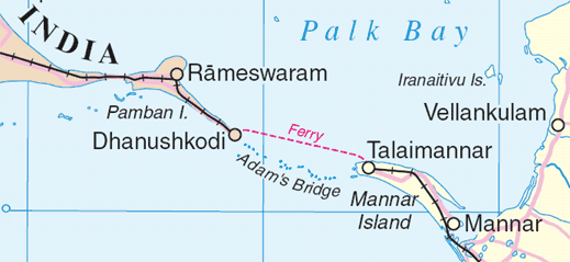
Map of en:Adam's Bridge, India/Sri Lanka
Extracted from www.un.org/Depts/Cartographic/map/profile/srilanka.pdf
| This image is a map derived from a United Nations map.
Unless stated otherwise, UN maps are to be considered in the public domain. This applies worldwide. UN maps are, in principle, open source material and you can use them in your work or for making your own map. UN requests however that you delete the UN name, logo and reference number upon any modification to the map. Content of your map will be your responsibility. You can state in your publication, if you wish, something like: based on UN map … (map name, map number, revision number and date). See: Geospatial Information Section. And: Geospatial, location data for a better world. |
 |
Faili ajalugu
Klõpsa kuupäeva ja kellaaega, et näha sel ajahetkel kasutusel olnud failiversiooni.
| Kuupäev/kellaaeg | Pisipilt | Mõõtmed | Kasutaja | Kommentaar | |
|---|---|---|---|---|---|
| viimane | 4. august 2006, kell 04:55 | | 519 × 239 (25 KB) | Gugganij | Map of Adam's Bridge, India/Sri Lanka Extracted from http://www.un.org/Depts/Cartographic/map/profile/srilanka.pdf {{UN map}} |
Faili kasutus
Seda faili kasutab järgmine lehekülg:
Globaalne failikasutus
Järgmised muud vikid kasutavad seda faili:
- Faili kasutus vikis ar.wikipedia.org
- Faili kasutus vikis az.wikipedia.org
- Faili kasutus vikis ba.wikipedia.org
- Faili kasutus vikis be.wikipedia.org
- Faili kasutus vikis bn.wikipedia.org
- Faili kasutus vikis cs.wikipedia.org
- Faili kasutus vikis de.wikipedia.org
- Faili kasutus vikis el.wikipedia.org
- Faili kasutus vikis en.wikipedia.org
- Faili kasutus vikis eo.wikipedia.org
- Faili kasutus vikis es.wikipedia.org
- Faili kasutus vikis fi.wikipedia.org
- Faili kasutus vikis fr.wikipedia.org
- Faili kasutus vikis fy.wikipedia.org
- Faili kasutus vikis gl.wikipedia.org
- Faili kasutus vikis gu.wikipedia.org
- Faili kasutus vikis he.wikipedia.org
- Faili kasutus vikis hu.wikipedia.org
- Faili kasutus vikis id.wikipedia.org
- Faili kasutus vikis it.wikipedia.org
- Faili kasutus vikis ja.wikipedia.org
- Faili kasutus vikis kn.wikipedia.org
- Faili kasutus vikis ko.wikipedia.org
- Faili kasutus vikis la.wikipedia.org
- Faili kasutus vikis lt.wikipedia.org
- Faili kasutus vikis mai.wikipedia.org
- Faili kasutus vikis mk.wikipedia.org
- Faili kasutus vikis ml.wikipedia.org
- Faili kasutus vikis new.wikipedia.org
- Faili kasutus vikis nl.wikipedia.org
Vaata selle faili globaalset kasutust.