Fail:1822 Geographical, Statistical, and Historical Map of Florida by Henry Charles Carey, Isaac Lea and Fielding Lucas.png

Selle eelvaate suurus: 498 × 599 pikslit. Teised eraldusvõimed: 199 × 240 pikslit | 399 × 480 pikslit | 804 × 967 pikslit.
Algfail (804 × 967 pikslit, faili suurus: 1,39 MB, MIME tüüp: image/png)
| See fail ja sellest kastist allapoole jääv kirjeldus pärinevad kesksest failivaramust Wikimedia Commons. | Faili lehekülg Commonsis |
Lühikirjeldus
| Kirjeldus |
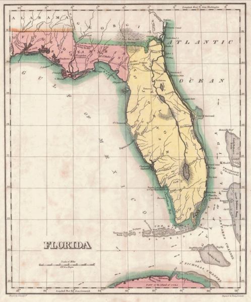
English: 1822 map of Florida Territory, published less then a year after Florida was ceded to the U.S. by Spain. The map delineates the territory's two original counties – Escambia and St. Johns, whose initial boundaries were conterminous with those of the earlier districts of East and West Florida. The interior river system is still largely anecdote and conjecture. Two roads lead west out of St. Augustine, one to Rollstown on the St. Johns River and the other to Ivitachua. A number of early northern forts are listed, including Ft. Barancas, Ft. Gadsden or Collinton, Ft. St. Marks, Ft. Poppa, Picolota Ft., and a British Fort erected during the war on the Apalachicola River. |
| Kuupäev | |
| Allikas |
Original publication: A Complete Historical, Chronological, And Geographical American Atlas, Being A Guide To The History Of North And South America, And The West Indies ... To The Year 1822. According To The Plan Of Le Sage's Atlas And Intended As A Companion To Lavoisne's Improvement Of That Celebrated Work." (Philadelphia, PA: Carey and Lea, 1822) |
| Autor |
Henry Charles Carey, Isaac Lea, Fielding Lucas |
- Other information
English: This is an image of an original map that is in the public domain. This image is not a derivative work of the original map, as it has not been improved through techniques such as cutting out backgrounds, fixing broken lines, simplification, sharpening or otherwise cleaning up.
Litsents
See fail on Ühendriikides avalikus omandis, sest see avaldati (või registreeriti USA autoriõiguse ametis) enne 1. jaanuari 1929.
Selleks et avaliku omandi teost saaks Commonsis hoida, peab selle autoriõiguse kehtivus olema lõppenud nii Ühendriikides kui ka päritoluriigis. Kui see ole Ühendriikide teos, siis peab selle juures olema ka autoriõiguse märgis, mis nätab, milline on teose autoriõiguslik staatus päritoluriigis.
|
Faili ajalugu
Klõpsa kuupäeva ja kellaaega, et näha sel ajahetkel kasutusel olnud failiversiooni.
| Kuupäev/kellaaeg | Pisipilt | Mõõtmed | Kasutaja | Kommentaar | |
|---|---|---|---|---|---|
| viimane | 30. jaanuar 2016, kell 16:16 | | 804 × 967 (1,39 MB) | Jeff in CA | re-cropped image |
| 30. jaanuar 2016, kell 13:40 |  | 830 × 984 (1,82 MB) | Jeff in CA | {{subst:Upload marker added by en.wp UW}} {{Information |Description = {{en|One of the earliest obtainable separate maps of Florida following its admission as a Territory in July 1821, the map pre-dates all but St. John's County, with the only delineat... |
Faili kasutus
Seda faili kasutab järgmine lehekülg:
Globaalne failikasutus
Järgmised muud vikid kasutavad seda faili:
- Faili kasutus vikis ar.wikipedia.org
- Faili kasutus vikis bn.wikipedia.org
- Faili kasutus vikis br.wikipedia.org
- Faili kasutus vikis en.wikipedia.org
- Faili kasutus vikis es.wikipedia.org
- Faili kasutus vikis gl.wikipedia.org
- Faili kasutus vikis he.wikipedia.org
- Faili kasutus vikis mt.wikipedia.org
- Faili kasutus vikis pt.wikipedia.org
- Faili kasutus vikis sr.wikipedia.org
- Faili kasutus vikis tr.wikipedia.org
- Faili kasutus vikis vi.wikipedia.org