Fail:Chquel-map-fr.png
Sellest suuremat pilti pole.
Chquel-map-fr.png (348 × 352 pikslit, faili suurus: 145 KB, MIME tüüp: image/png)
| See fail ja sellest kastist allapoole jääv kirjeldus pärinevad kesksest failivaramust Wikimedia Commons. | Faili lehekülg Commonsis |
Lühikirjeldus
| Kaamera asukoht | | See ja teised pildid sellest paigast lehel: OpenStreetMap |
|---|
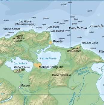
| Kirjeldus | Topographic map in French of the Gulf of Tunis, Tunisia, with indication of the nature of the sea bottom |
| Kuupäev | |
| Allikas |
Own work ; Topographic map : NASA Shuttle Radar Topography Mission (SRTM3 v.2) (public domain) edited with dlgv32 Pro and vectorized with Inkscape ; UTM projection ; WGS84 datum ; shaded relief (composite image of N-W, W and N lightning positions) ; References used for bathymetry and additional data : * 1:250,000 U.S. Army maps (printed 1956) ; * Google Earth ; * Locator map : Image:Tunisia.svg (modified) created by Philip Ronan (in PD) Approximate scale of topographic data and shore / lakes limits : 1:372,000 ; Note : The shaded relief is a raster image embedded in the SVG file which increases its size. If you want a lighter map for other purposes, delete the shaded relief image in your file. |
| Autor | Eric Gaba (Sting) |
| Luba (Faili edasikasutus) |
Attribution and Share-Alike required |
base source: http://commons.wikimedia.org/wiki/Image:Tunis_Gulf_topo_map-fr.svg
Français : * Sujet : Carte topographique en français du Golfe de Tunis, avec indication de la nature des fonds marins ;
- Sources : Création personnelle
- Données topographiques : NASA Shuttle Radar Topography Mission (SRTM3 v.2) (domaine public) édité avec dlgv32 Pro et vectorisé avec Inkscape ; projection UTM ; WGS84 datum ; relief ombré (image composite d'éclairages du N-O, O et N) ;
- Références utilisées pour la bathymétrie et les données complémentaires :
- Cartes au 1:250 000e de l'U.S. Army (imprimées en 1956) ;
- Google Earth ;
- Carte de localisation : Image:Tunisia.svg (modifiée) créée par Philip Ronan dans le domaine public ;
- Échelle approximative : 1:372 000 (données topographiques et tracés des côtes / lacs) ;
- Note : Le relief ombré est une image bitmap encapsulée dans le fichier SVG qui augmente son poids. Si vous avez besoin d'une carte plus légère pour d'autres utilisations, supprimez l'image du relief ombré dans votre fichier ;
- Auteur : Eric Gaba (fr:Sting) ;
- Date : Octobre 2007.
Litsents
Autoriõiguse omanikuna avaldan selle teose järgmiste litsentside all:

|
Luba on antud selle dokumendi kopeerimiseks, avaldamiseks ja/või muutmiseks GNU Vaba Dokumentatsiooni Litsentsi versiooni 1.2 või hilisema Vaba Tarkvara Fondi avaldatud versiooni tingimuste alusel; muutumatute osadeta, esikaane tekstideta ja tagakaane tekstideta. Sellest loast on lisatud koopia leheküljel pealkirjaga "GNU Free Documentation License". |
See fail kuulub Creative Commonsi jurisdiktsiooniga sidumata litsentsi "Autorile viitamine + jagamine samadel tingimustel 3.0" ning üldise litsentsi "Autorile viitamine + jagamine samadel tingimustel" versioonide 2.5, 2.0 ja 1.0 alla.
- Tohid:
- jagada – teost kopeerida, levitada ja edastada
- kohandada – valmistada muudetud teoseid
- Järgmistel tingimustel:
- omistamine – Pead materjali sobival viisil autorile omistama, tooma ära litsentsi lingi ja märkima ära, kas on tehtud muudatusi. Sobib, kui teed seda mõistlikul viisil, kuid seejuures ei tohi jääda muljet, et litsentsiandja tõstab esile sind või seda, et sina materjali kasutad.
- sarnaselt jagamine – Kui töötled, kujundad ümber või arendad materjali edasi, siis pead oma töö levitamiseks kasutama sama litsentsi, mille all on algupärand, või ühilduvat litsentsi.
Sa võid valida endale sobiva litsentsi.
Faili ajalugu
Klõpsa kuupäeva ja kellaaega, et näha sel ajahetkel kasutusel olnud failiversiooni.
| Kuupäev/kellaaeg | Pisipilt | Mõõtmed | Kasutaja | Kommentaar | |
|---|---|---|---|---|---|
| viimane | 17. juuli 2008, kell 03:18 | | 348 × 352 (145 KB) | Ori~ | {{Information |Description= |Source= |Date= |Author= |Permission= |other_versions= }} |
| 17. juuli 2008, kell 03:16 |  | 849 × 768 (699 KB) | Ori~ | base source: http://commons.wikimedia.org/wiki/Image:Tunis_Gulf_topo_map-fr.svg == Summary == {{Location|37|00|00|N|10|30|00|E|scale:500000}} {{Information |Description=Topographic map in French of the Gulf of Tunis, Tunisia, with i |
Faili kasutus
Seda faili kasutavad järgmised 2 lehekülge:
Globaalne failikasutus
Järgmised muud vikid kasutavad seda faili:
- Faili kasutus vikis he.wikipedia.org
- Faili kasutus vikis lv.wikipedia.org
- Faili kasutus vikis sv.wikipedia.org